

Fox's Wharf
Fox's Wharf is a low water wharf at Lower Gagetown in the Village of Arcadia, across from the western edge of Upper Musquash Island.


This week’s wharf profile is the sixth in a series of collaborations with the St. John River Society. Initially acquired when the Department of Fisheries and Ocean’s Small Craft Harbour Program began divesting itself of derelict, low activity, and/or recreational wharves in the late 1990s, the St. John River Society took ownership of thirteen steamboat wharves to maintain public access to the river. The Society’s public wharves are undergoing major repairs this summer through a $970,000 grant from the Canada Community-Building Fund. Subscribe for free to receive future profiles directly in your inbox or check out the archived wharf profiles on previous Society wharves including Bedford, Gerow’s, Hampstead, Public Landing, and Maugerville.
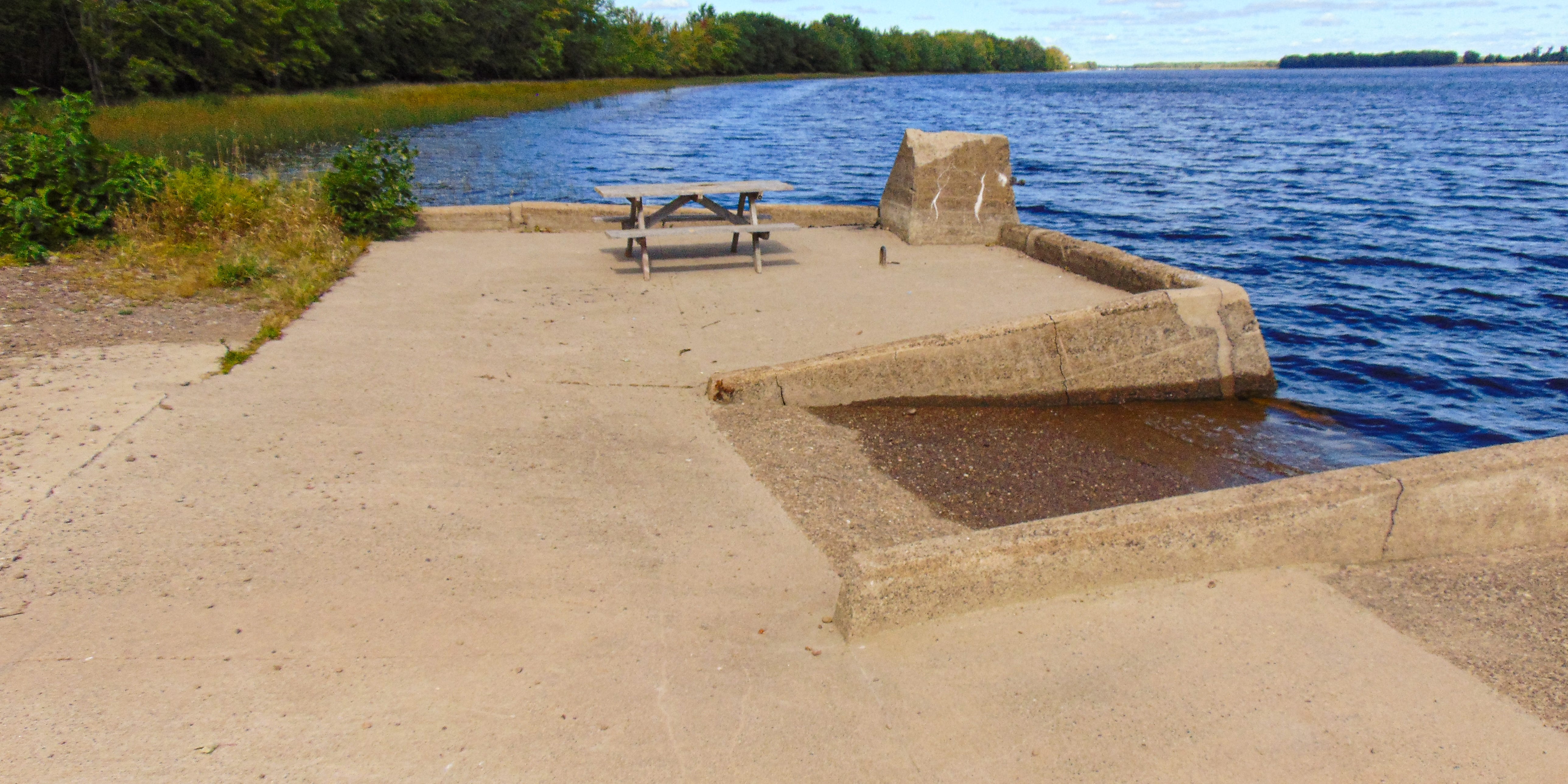
Fox’s Wharf is a small, 16 meter-wide low water wharf. The concrete wharf itself is only 10 meters long, but it sits at the end of a much larger rocky wharf approach that extends from the end of Fox Road. Either side of the approach has become overgrown over the years, disguising the approach’s status as a man-made structure.

The upriver side of the wharf has a pitched ice guard, which has split near the front allowing a section of the wall to sink about half a foot. The upriver corner pier has also been damaged by the elements, with a chunk of the top having been broken off.

The downriver corner pier is similarly angled, although in this case it appears that the pitched wall has been far more effective as the pier is in relatively pristine condition.

Given the wharf’s diminutive scale, the bulk of the wharf is dominated by the central slipway. The slip occupies about a third of the wharf face’s total width.

The most unique feature of the Fox’s Wharf is its small craft access stair. The stair is not only small, but oriented perpendicularly to the downriver wall. Each step offers barely any space to stand.

The first reference to Fox’s Wharf appears to be a special expenditure on account of repairs to the wharf at Lower Gagetown.1 Lower Gagetown and Fox’s appear to be used interchangeably up until the transfer of the wharf’s ownership from the provincial government to its federal counterpart. Records in 1902, 1911, 1913, 1915, and 1918 all refer to Fox or Fox’s Wharf, while records from 1878, 1909, 1917 refer to Lower Gagetown.2
When the federal government formally assumed control of the wharf in 1924, it was reported to be in bad condition and was quickly rebuilt. This work resulted in the wharf taking on essentially the same design still visible today:
The outer face and sides were rebuilt from low-water level over the old cribwork, with concrete in the form of a wall 5.7 feet high and 3 feet 8 inches thick along the front and lower side, and a slab 18 inches thick laid over the old ice slip, for a length of 32 feet, on the upper side.3
The wharf remained in fairly good condition over the next few decades. The Sailing Directions for 1965 and 1976 reported no significant state of disrepair, 4and the only development from 1984 to 2009 was a note that the deck of the wharf was partially overgrown.5 In 1964, the wharf was even included among a list of 26 wharves owned by the federal government along the Lower Wolastoq and its tributaries that were considered readily adaptable for use by small non-commercial boats in a proposal by Royal M.P., R.G.L. Fairweather to redevelop the wharf system for use by pleasure-craft.6

Fox's Wharf is a unique case among the St. John River Society's wharves in that it was not acquired in the initial wharf divestment. Rather, Fox's Wharf came under the Society's control over a decade later in 2012. As a Society wharf, Fox’s will benefit from the ongoing repair initiative and is scheduled for repairs alongside the Maugerville Wharf covered last week.7
Twenty-Fourth Annual Report of the Chief Commissioner of Public Works, New Brunswick 1878 in Journal of the House of Assembly of the Province of New Brunswick (Saint John, New Brunswick: George W. Day, 1878), 7.
Forty-Eighth Annual Report of the Chief Commissioner of Public Works, New Brunswick 1902 in Journal of the House of Assembly of the Province of New Brunswick (Fredericton, New Brunswick: [Printer information obscured in scan from Legislative Library], 1903), 74; Fifty-Seventh Annual Report of the Chief Commissioner of Public Works, New Brunswick 1911 in Journal of the House of Assembly of the Province of New Brunswick (Fredericton, New Brunswick: [Printer information obscured], 1912), 28; Fifty-Ninth Annual Report of the Chief Commissioner of Public Works, New Brunswick 1913 in Journal of the House of Assembly of the Province of New Brunswick (Fredericton, New Brunswick: [Printer information obscured], 1914), 28; Sixty-First Annual Report of the Chief Commissioner of Public Works, New Brunswick 1915 in Journal of the House of Assembly of the Province of New Brunswick (Fredericton, New Brunswick: [Printer information obscured], 1915), 31; Sixty-Fourth Annual Report of the Chief Commissioner of Public Works, New Brunswick 1918 in Journal of the House of Assembly of the Province of New Brunswick (Fredericton, New Brunswick: [Printer information obscured], 1919), 41; Fifty-Fifth Annual Report of the Chief Commissioner of Public Works, New Brunswick 1909 in Journal of the House of Assembly of the Province of New Brunswick (Fredericton, New Brunswick: [Printer information obscured], 1910), 89; Sixty-Third Annual Report of the Chief Commissioner of Public Works, New Brunswick 1917 in Journal of the House of Assembly of the Province of New Brunswick (Fredericton, New Brunswick: [Printer information obscured], 1918), 31.
Report of the Minister of Public Works on the Works Under his Control for the Fiscal Year Ended March 31, 1925 — Chief Engineer’s Report in Annual Departmental Reports 1924-25 Volume 6 (Ottawa, Ontario: F. A. Ackland, Printer to the King’s Most Excellent Majesty, 1925), 33.
Canadian Hydrographic Service, Saint John River Pilot from Saint John Harbour to Fredericton with Grand Lake and Kennebecasis Bay (Ottawa: Canadian Hydrographic Service, 1965), 30; Canadian Hydrographic Service, Small Craft Guide Saint John River, 1st ed. (Ottawa, Ontario: Department of the Environment, 1976), 59.
Canadian Hydrographic Service, Small Craft Guide Saint John River, 3rd ed. (Ottawa, Ontario: Department of the Environment, 1984, 64.
R.G.L. Fairweather, “Letter to the Editor,” Telegraph-Journal, October 12, 1964, https://da.tj.news/viewer?opub=Telegraph_Journal&date=19641012&page=5&search=taylortown&filename=0212_TJ_A9617.
Correspondence with Ed Coy, member of the St. John River Society’s wharf preservation committee on September 5, 2024.