


Public Landing Wharf

Public Landing is a graded wharf on the Long Reach of the Lower Wolastoq in the Fundy Rural District.

This week’s wharf profile will be the first in a series of collaborations with the St. John River Society. Initially acquired when the Department of Fisheries and Ocean’s Small Craft Harbour Program began divesting itself of derelict, low activity, and/or recreational wharves in the late 1990s, the St. John River Society took ownership of thirteen steamboat wharves to maintain public access to the river. The Society’s public wharves are undergoing major repairs this summer through a $970,000 grant from the Canada Community-Building Fund.1

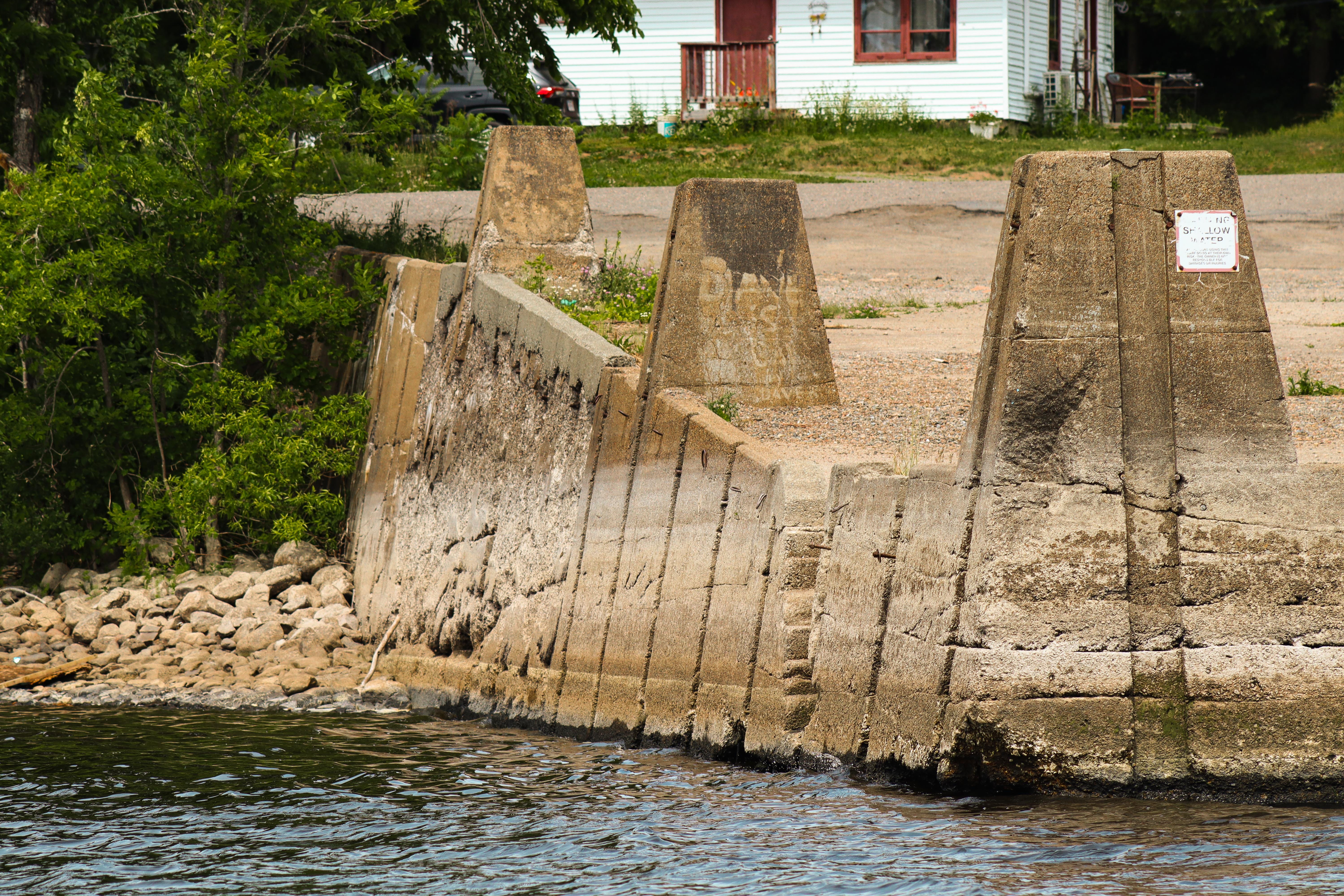
Public Landing is a graded wharf about 15 meters wide and 48 meters long. It features six inset bollards, three on either side of the deck. Compared with other wharves covered in previous weeks such as Newcastle Creek, Public Landing’s bollards display an abnormal level of ornamentation. The engraved name is larger than average and two other bollards feature three-letter acronyms: H, A, and L and A, M, and W. I’m not sure what these letters refer to — I have only seen them on the Public Landing and Days Landing wharves. Readers with any insights on these acronyms are encouraged to share their thoughts below.
The wharf also features a pair of small craft access points, one on each side of the deck. Although small — both staircases are barely a foot wide without a landing platform — the presence of a pair of stairs reflects an emphasis on multipurpose use not necessarily prioritized at other wharves. This symmetrical design complements the St. John River Society’s promotion of recreational river access as a key programming pillar.
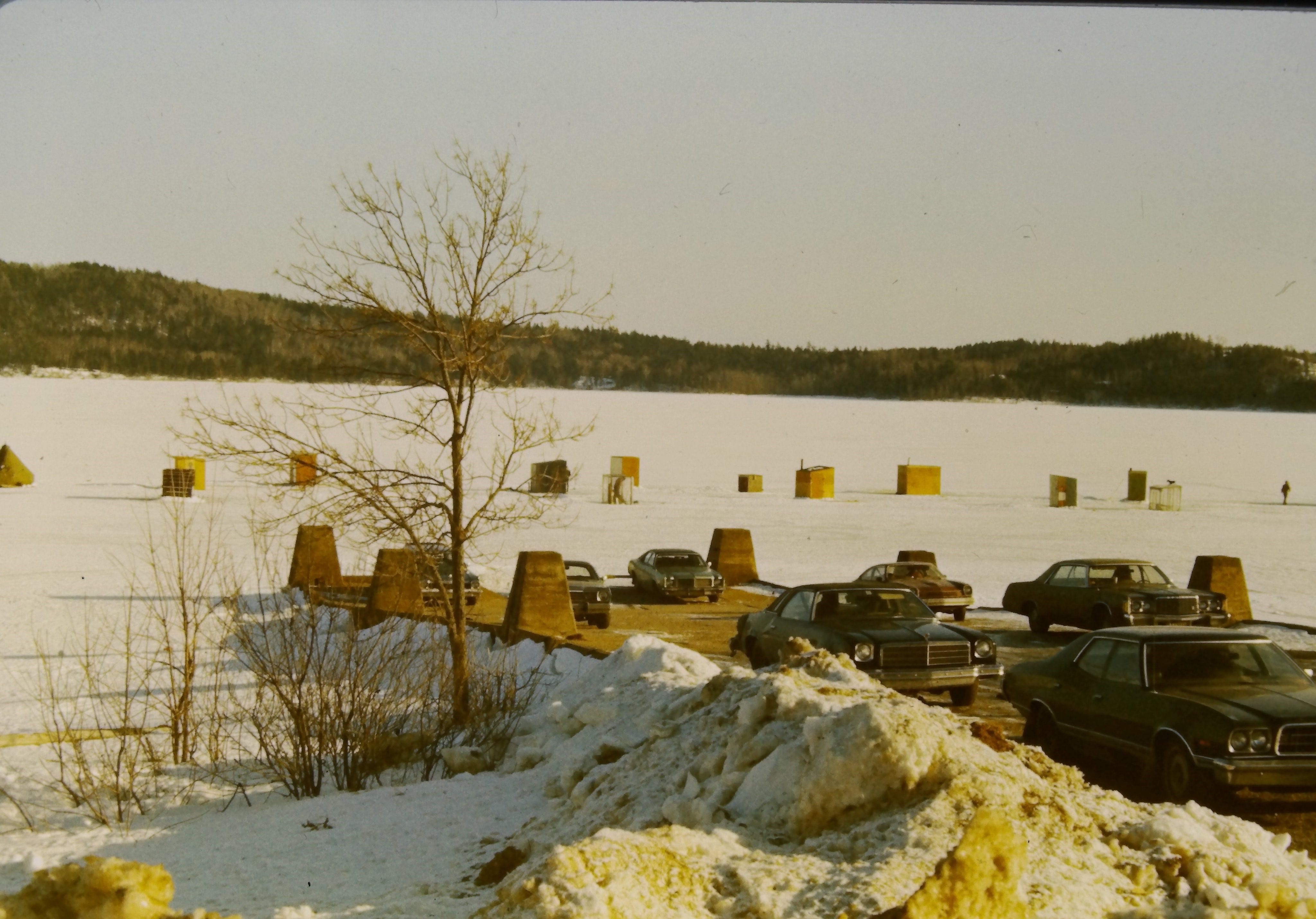
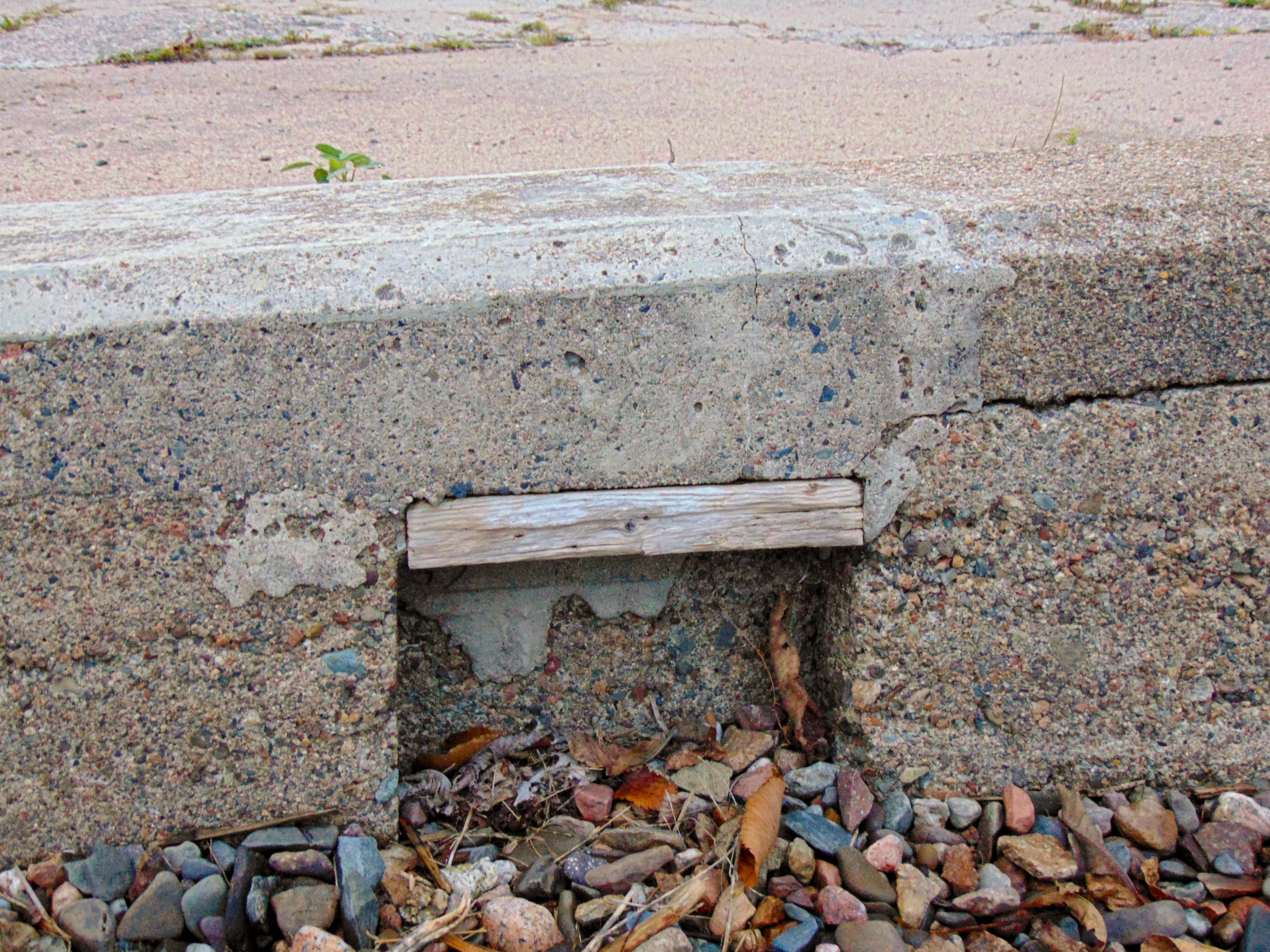
Today a boulder obstructs the cargo slip to deter vehicles from mounting the deck or driving onto the ice in the winter, but in the past the wharf would fill with cars during the ice fishing season as a village of fishing shacks would spring up in front of the wharf — a rarer sight today given the poor ice conditions over the last few winters.
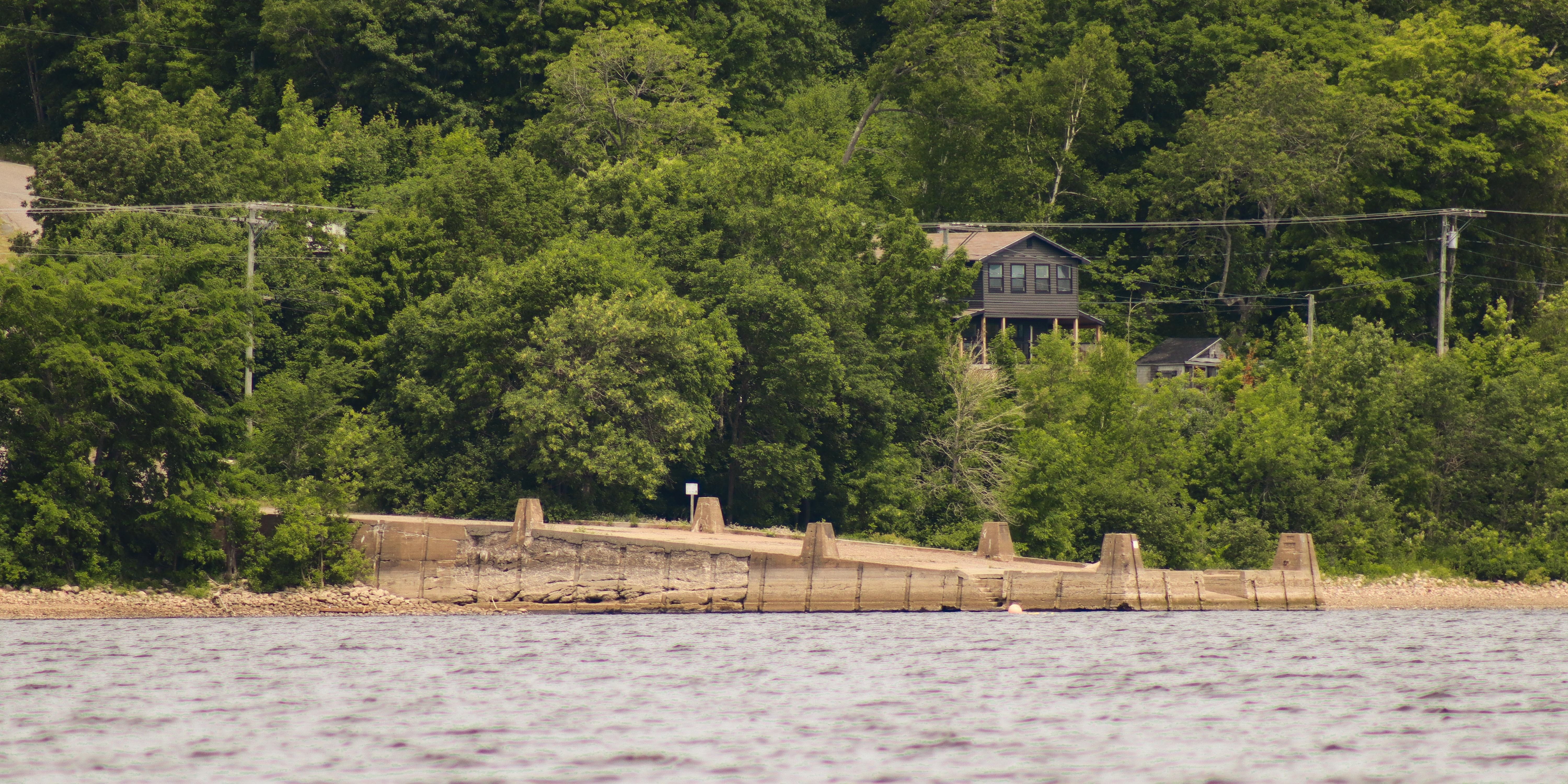
Public Landing Wharf is one of eight wharves on the northern shore of the Long Reach, a section of the Lower Wolastoq that runs parallel to the Kennebecasis River along the Kingston Peninsula. When approaching from upriver, the wharf appears to extend only a few meters from shore because the berth area has become infilled with sand. This accumulation has mostly occurred since the wharf was upgraded with concrete in 1928, as evidence by the presence of small craft access points and grooves for fender timbers along both the upriver and downriver side walls.
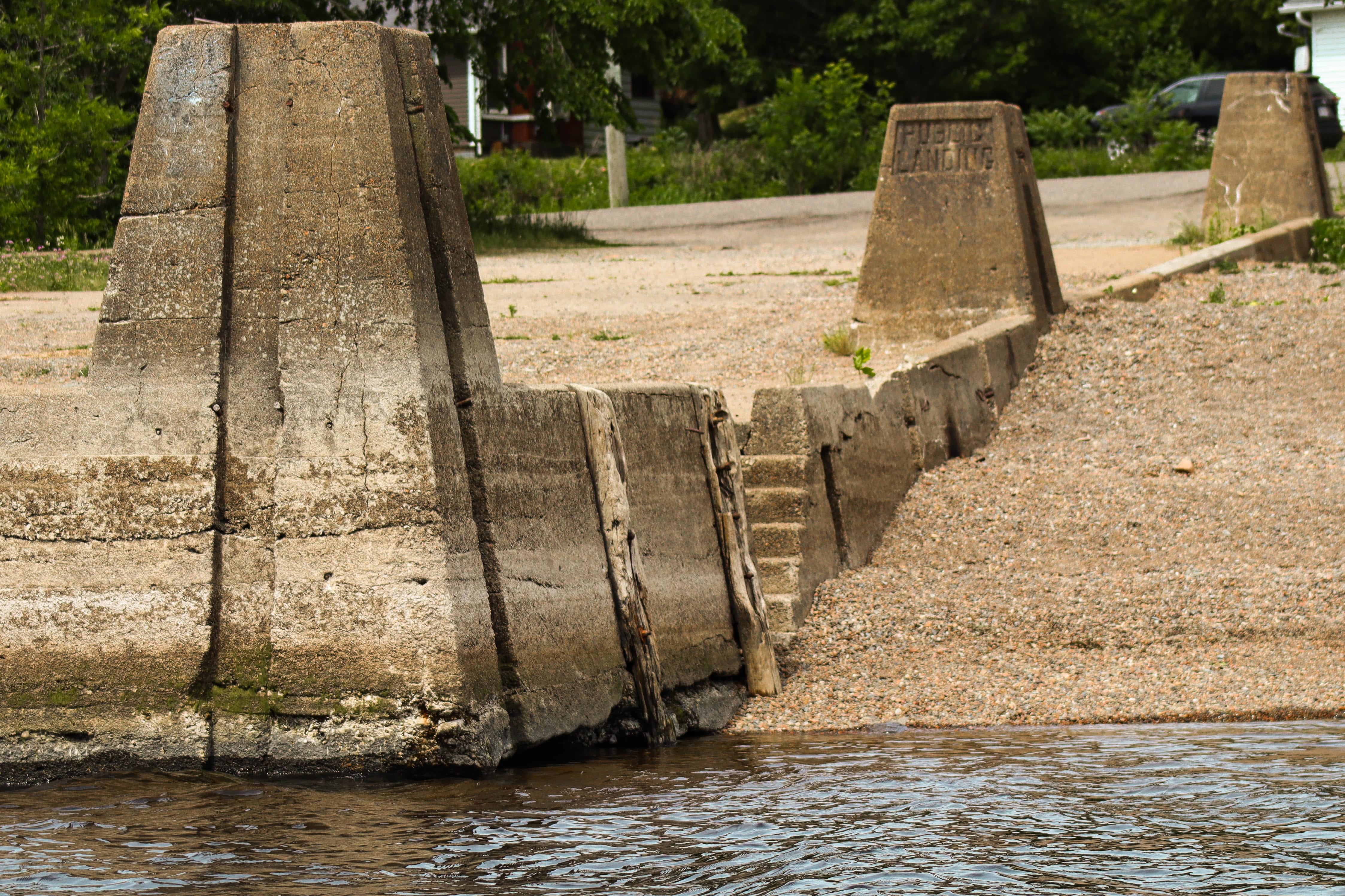
It is unclear how the generic term “Public Landing” came to be associated exclusively with this wharf. While some landings appear to have been owned by steamer companies or individuals, the majority of steamboat wharves on the Lower Wolastoq were government-owned and could justifiably be refered to as “public landings”.
The Public Landing Wharf first appears in provincial Public Works records in 1901, however, the local Post Office was named Public Landing as early as 1889 so the $556.74 expended in 1901 could also have been for an extensive retrofit of an older wharf rather than a new build.2 Minor repairs are reported between 1901 and 1910,3 but no descriptions of these repairs or of the wharf itself are provided in this period. An inspection of the wharf performed by A. W. Day in 1912 identifies Public Landing as a high and low water wharf,4 but this may be in reference to the plans for the reconstruction of the wharf planned for the following fiscal year rather than a description of the wharf as it was from 1901 to 1912.5
Although F. L. Boone was awarded the contract to either construct or extensively repair the “Public Landing high and low water wharf” at a cost of $3940 in 1912, the Annual Report for 1913 lists all work as having been done by W. E. Cronk instead.6 Given that F. L. Boone had also been awarded a contract to construct the low water wharf at Sand Point the same year it is possible that complications arising in that project prevented him from fulfilling his contract at Public Landing.7 By contrast, W. E. Cronk not only led on work at Public Landing but also performed repairs at the Jenkins, Clifton, Earle’s, Oak Point, Brown’s Flats, Glenwood, Victoria, Carter’s Point, Cedars, Shampers, Bedford, Dunham’s, Perry’s Point, Williams, Moss Glen, Fulton, and Nutters wharves all in the same year.8

It is unclear when — or even if — the wharf was refitted as a graded wharf. It is possible that in this context “high and low water” was simply intended to mean graded as the description of work provided by the federal public works department in 1928 makes no reference to leveling two distinct high and low water decks:
The old cribwork faces on the outer end of the wharf were removed for lengths of 110 feet on the upper side and 61 feet on the lower, and replaced with concrete walls. A slip was made in the outer end, and landing steps were built in both the side walls. A concrete floor was laid over the outer 30 feet, and concrete walks were constructed on the upper and lower sides, 80 by 10 feet and 31 by 6 feet, respectively. The stone-filled section was surfaced with gravel and five concrete fender piers [bollards] were built.9
Further work was carried out in 1930, and although I have not yet managed to access any descriptions of this work, given that the cost of repairs was comparable to that of the initial refurbishment in 1928 — $2800 and $3000 respectively — it is likely that the work was more extensive than simply adding the sixth bollard present today.10
Today, the wharf is actively maintained by the St. John River Society and serves as a hub for various recreational activities. The Society has already left their mark on the wharf with repairs conducted since their acquisition of the wharf in the early 2000s. Beyond the wharf’s overall good condition, astute visitors may also notice the caps on the fender grooves as evidence of 21st century repair work. Repairs like this which alter the original functionality of now-redundant design features are especially interesting to me because they reflect the wharves’ changing function: these structures are now fundamentally for recreational use. The steamers may be gone, but the wharves are still useful.
Although all thirteen wharves in the St. John River Society’s network are important components of their local communities, the preservation of the Public Landing Wharf feels like an especially vital endeavor. Unlike other communities like Hampstead or Queenstown whose wharves derive their names from their location, Public Landing’s identity is inextricably linked to this wharf. As was noted in last week’s profile of the Upper Jemseg Wharf, these structures endurance into the 21st century was by no means guaranteed.
Jeanne Armstrong, “A century ago, river wharfs were a lifeline for residents. Now they’re getting a facelift,” CBC News, July 24, 2024, https://www.cbc.ca/news/canada/new-brunswick/saint-john-river-wharfs-facelift-1.7272506.
Forty-Seventh Annual Report of the Chief Commissioner of Public Works, New Brunswick 1901 in Journal of the House of Assembly of the Province of New Brunswick (Fredericton, New Brunswick: L.B. Williams, 1902), 20; Alan Rayburn, Geographic Names of New Brunswick (Ottawa, Ontario: Canadian Permanent Committee on Geographic Names,1975), 225.
Forty-Seventh Annual Report, 20; Forty-Eighth Annual Report of the Chief Commissioner of Public Works, New Brunswick 1902 in Journal of the House of Assembly of the Province of New Brunswick (Fredericton, New Brunswick: [Printer information obscured in scan from Legislative Library], 1903), 20; Fifty-Fourth Annual Report of the Chief Commissioner of Public Works, New Brunswick 1908 in Journal of the House of Assembly of the Province of New Brunswick (Fredericton, New Brunswick: [Printer information obscured], 1909), 47; Fifty-Sixth Annual Report of the Chief Commissioner of Public Works, New Brunswick 1910 in Journal of the House of Assembly of the Province of New Brunswick (Fredericton, New Brunswick: [Printer information obscured], 1911), 26;
Fifty-Eighth Annual Report of the Chief Commissioner of Public Works, New Brunswick 1912 in Journal of the House of Assembly of the Province of New Brunswick (Fredericton, New Brunswick: [Printer information obscured], 1913), 26.
Fifty-Eighth Annual Report, 129.
Fifty-Ninth Annual Report of the Chief Commissioner of Public Works, New Brunswick 1913 in Journal of the House of Assembly of the Province of New Brunswick (Fredericton, New Brunswick: [Printer information obscured], 1914), 26.
Fifty-Eighth Annual Report, 129.
Fifty-Ninth Annual Report, 25-26.
Report of the Minister of Public Works on the Works Under his Control for the Fiscal Year Ended March 31, 1929 — Chief Engineer’s Report in Sessional Papers of the Fifth Session of the Eighth Parliament of the Dominion of Canada Volume 4 (Ottawa, Ontario: F.A. Acland, Printer to the King’s Most Excellent Majesty, 1930), 44.
Peter Cronk Malmberg, Steam Transportation on the Saint John River 1816-1946 (Fredericton, New Brunswick: University of New Brunswick, 1990), 58.